Water Supply Repair
Work starts on the 15th August to repair and improve our existing water supply.
The current weir structure which provides water to our Centre is in a poor state of repair and condition. Surveys have demonstrated that the structures are likely to fail in the short term without significant refurbishment work.
Planning permission was granted in 2023 after engagement with consultees (SEPA, CNPA, FLS, Highland Council, NatureScot) and the project should last approximately 9 weeks. Included in the project is temporary track widening towards Lochan na Frithe, most of which will be reinstated after the project has completed. There will also be a temporary welfare site located near the track for the duration of the project.
It is anticipated that the project will be completed and all re-instatement work concluded by the end of October.
What is happening?
We are refurbishing our existing weir and intake chamber, which supplies our drinking water. This is an existing water supply to the Lodge and no change to the amount of water being taken from the river is proposed. The existing weir structure is in a poor state of repair, with areas of concrete within the river having been damaged and / or washed away. Exposed steel reinforcement within the remaining concrete apron downstream of the weir is unsightly and could pose a danger to fish and other wildlife. The weir and associated chamber are likely to suffer structural failure, leading to the loss of water supply if significant refurbishment work is not conducted soon. Alongside the proposed refurbishment, changes will be made to improve the operation and maintenance of the structure.
Will the public still be able to access the walking tracks in the area?
Yes.
The site is in close proximity to the GR9 Glenmore Lodge (off road route – see image below) Core Path. Public access along this route and other core paths beyond the site is protected and any traffic associated with the project will adhere to a strict traffic management plan, to reduce impact.
Project timings
The project is due to start mid August and will be completed by end of October, as stipulated by consultees: Highland Council, SEPA, CNP, Nature Scot, FLS. Work is scheduled to take place at a time which sees the least impact on wildlife.
Will there be any visible signs of work?
There will be a temporary widening of the existing access track which leads up from the path (see map below) This will be reinstated afterwards.
There is also the construction of a small section of track to the intake site. This will run from the existing forest road to Lochan na Frithe across open ground to the intake and isn’t visible from the core path. The route has been selected to avoid the need to remove any mature trees or to impact upon their Root Protection Areas, though some younger trees will be felled. The track will be formed by stripping the existing vegetation and topsoil which will be placed to one side for use in reinstatement. The track will be formed by winning suitable material locally from within the construction corridor and the shoulder that the track cuts through en-route to the intake. There will also be a temporary welfare unit installed.
Post project reinstatement plan
The following measures are amongst those that will be taken post project to reinstate the tracks and construction compounds:
•The new tracks will be reduced in width to 1.5m, suitable for ATV use, using locally won soil and vegetation
• Bracken areas adjacent to the track to the intake will be scarified to encourage natural regeneration.
• The start of both the new track to the intake and the existing Allt na Frithe track are to be ‘disguised’ or access discouraged.
Anticipated mitigations may include:
• Placing locally won soil and vegetation (e.g. heather) on the new track where it is within site of the existing track.
• Placing boulders at the start of the track to discourage vehicle access.
• The final restoration will be planned to include mitigation of the visual impact of the work.
Location Plan:
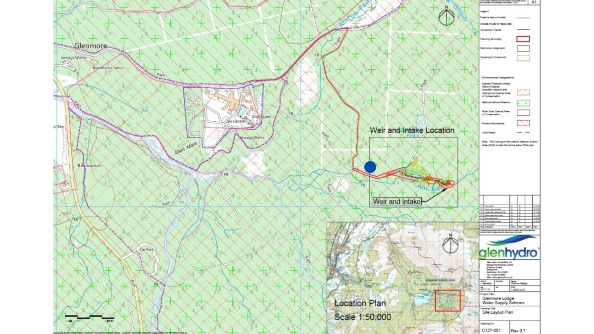
Blue mark: Location of temporary track widening
Any questions contact [email protected]